bathymetry charts
bathymetry charts
Does anyone know where I can find detailed bathymetry charts for discovery bay?
Re: bathymetry charts
better said --- bathymetic charts
Re: bathymetry charts
Define "detailed"?
The most detailed bathymetry published is Chart 18471 which is available online and at resellers like Captain's Nautical Supplies, West Marine, and Armchair Sailor
http://www.charts.noaa.gov/OnLineViewer/18471.shtml
The most detailed bathymetry published is Chart 18471 which is available online and at resellers like Captain's Nautical Supplies, West Marine, and Armchair Sailor
http://www.charts.noaa.gov/OnLineViewer/18471.shtml
Sounder wrote:Under normal circumstances, I would never tell another man how to shave his balls... but this device should not be kept secret.

Re: bathymetry charts
This represents a similar level of detail in a different format:
http://www.ocean.washington.edu/data/pu ... m2005.html
The 61.9 mb pdf is the one to look at. I can't spot the Warhawk on it but Ed's fault shows up well and there are some other interesting things to look at in Discovery Bay in this file.
http://www.ocean.washington.edu/data/pu ... m2005.html
The 61.9 mb pdf is the one to look at. I can't spot the Warhawk on it but Ed's fault shows up well and there are some other interesting things to look at in Discovery Bay in this file.
-
sitkadiver
- Submariner
- Posts: 505
- Joined: Fri Feb 22, 2008 2:33 pm
Re: bathymetry charts
4ster wrote:This represents a similar level of detail in a different format:
http://www.ocean.washington.edu/data/pu ... m2005.html
The 61.9 mb pdf is the one to look at. I can't spot the Warhawk on it but Ed's fault shows up well and there are some other interesting things to look at in Discovery Bay in this file.
pdf format? very cool...
So, the NOAA boat that was here in SE Alaska in 2005, 2006 and 2007 was supposedly working Puget Sound during the winter months. Would probably be worth a few minutes to check out NOAA.gov. I have'nt been to the site in a while, so I'll check it later tonight for you. Of course I'll be looking at that UW site as well.
I do not believe in taking unnecesary risks, but a life without risk is not worth living.
-Charles Lindbergh
-Charles Lindbergh
Re: bathymetry charts
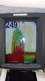
Very cool charts. I now realize the depths of my dilemma, pun intended. I grew up on PT and we have a family cabin on the west shore of Beckett Point and are new boat owners. I was hoping to put a mooring buoy in front of the cabin so that we could use the boat without having to take it in and out all the time when we have the opportunity to visit in the summers. We don't really have a vehicle there we can use to do that. But the underwater slope looks pretty steep. It appears as if it drops 100 feet in 100 yards.
I am thinking the mooring anchor would have to be in 100 ft or less of water so that I could dive it and maintain it every year. Any idea how to figure out how far off shore I would need to be with the tides, proper anchor line slope, etc?
Also, I am going to be in PT the 2nd week in Feb and was thinking of maybe diving in front of the cabin to see what the underwater landscape really looks like there. Any idea how I could set that up with a local dive shop? I am a long time diver ~150 dives, but have never dived in the NW / cold water.
Re: bathymetry charts
Do you own the tidelands there at Beckett Point? Your best best is talking about this with your cabin neighbors and the HOA. Figure out who and how they installed their moorings, what hasn't worked and what has worked. Emulate neighboring successful installations. I'm sure its not going to be simple.
Sounder wrote:Under normal circumstances, I would never tell another man how to shave his balls... but this device should not be kept secret.
Re: bathymetry charts
Thanks. Good advice. I have talked to one was lucky enough to find some abandoned dead weight anchors in front of their place and were able to make a 2 point anchor system. That should work well on the slope there which starts out gradual and then steepens. When the boat is pulling out to sea it is pulling on the shallow anchor. When it is pulling toward shore it is trying to drag the deeper anchor up the hill. I am hoping to dive the site in Feb. when I am there to get a better idea what's on the bottom.