We may have actually found this, but it ain't much. It doesn't look like anything that ever once floated and more a large 20'x20' concrete mooring block. It is consistent with having been down there since 1972, though, since it is encrusted with metridiums.VESSEL: Barge
AWOIS RECNO: 53524
GPS LAT: 47.555930555556
GPS LNG: -122.40332222222
GPS QUALITY: Med
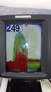
AWOIS DEPTH: N/A
PSDEM DEPTH: 25
HISTORY:
CL1054(72) 1972; Department of Transportation offical correspondance reports the wreck of a barge in Lat. 47/33/22 Lon. 122/24/07.5 NAD27. The intention of the owners is to abandon barge in place. The wreck is reported to be in 33 feet of water with 23 feet of water over the wreck at MLLW. The USCG does not entend to establish a wteck buoy or other marker. (KRW 11/03/06)
To start with we dropped in at low tide which was interesting. I suggest doing this site closer to high water. We had to hike a long ways out and then had to scooter on the surface quite a ways out. We finally found some deeper water and dropped down and found a roughly 33 fsw contour. We immediately found huge fields of sea pens, along with sea stars and big fat looking nudibranchs chowing down on them. At 10 minutes running along the contour at 33 fsw we hit a small tire reef that was also encrusted and had a huge swarm of shrimp fry hanging out in the middle of it. At about 18 minutes runtime along the contour we found the mooring block (about 3k feet south of the mee kwa mooks entrance). We went another 5 minutes south and didn't find anything else. We turned and went back deeper and picked up the fishing reef. Laura saw a medium-big (10') sixgill right when we got to the reef, but it shot off and was gone before I saw it.
Laura had her vid camera, so stay tuned for the youtube link when she's done putting it together...
If anyone else goes back down there and wants to try to find the tires or the block at *high* tide, remember that you need to spend 5 minutes extra swimming offshore until you get through all the eel grass and that other junk that got in my props. And then it'll be a 43 foot contour closer to high tide than a 33 foot contour.
If anyone finds something that looks more like a barge, lemme know as well... I'm curious if we found the mooring block but missed the wreck... We went by the block on the deep end, but didn't check what was on the shallow end...